Current Projects
Lower Columbia Chum Strategic Action Plan
Project Summary: Columbia River Chum is a federally listed species in population decline. Chum habitat improvement and revival of native Chum populations is a priority of the Oregon’s Conservation and Recovery Program, though no regional restoration plan currently exists. The goal of this project is to create a Strategic Action Plan (SAP) for chum salmon in the Youngs Bay and Big Creek watersheds and allow committed local partners to pursue strategic restoration actions in an effective and collaborative way.
An SAP with a watershed-level approach will enable concentrated efforts into high priority areas, design projects that will improve stream function on a meaningful landscape scale (beyond conditions of the localized project sites), connect previously completed restoration project areas and create larger sections of high-functioning habitat. The SAP will describe high priority areas for habitat improvement, potential activities that would benefit Chum spawning and rearing habitat (i.e. stream bank planting) and bring in additional partners to maximize resources.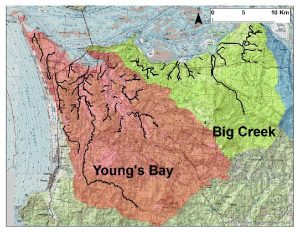
Project Partners: Oregon Department of Fish and Wildlife (ODFW), Lewis and Clark National Historical Park (LEWI), Columbia River Estuary Study Taskforce (CREST), National Oceanic and Atmospheric Administration (NOAA), US Fish and Wildlife Service (USFWS), and Hampton Lumber
Check out ODFW’s site dedicated to Chum recovery or read about Chum Recovery Efforts.
Project Funders: Oregon Watershed Enhancement Board: $74,465; in-kind match funds from all project partners
Total Cost of Project: $110,369
Completion Year: 2021
Lower Columbia Chum Landowner Outreach
Project Summary: All projects implemented with the North Coast Watershed Association are completely voluntary. As a non-regulatory organization, we conduct all activities and programs with willing landowner partners. To dovetail with the Chum Strategic Action Plan project, the Chum Landowner Outreach project will focus on engaging landowners in specific regions of the watershed.
This project will give NCWA the time to invest into landowner conversations and carefully listen to landowner needs and desires while developing the Chum Strategic Area Action Plan and creating habitat restoration projects that match landowner values. If this project is successful NCWA will have a list of willing landowners, stakeholders and additional partners committed to implementing river adjacent projects to improve chum habitat.
Project Partners: Oregon Department of Fish and Wildlife (ODFW), Lewis and Clark National Historical Park (LEWI), Columbia River Estuary Study Taskforce (CREST), National Oceanic and Atmospheric Administration (NOAA), US Fish and Wildlife Service (USFWS), and Hampton Lumber
Project Funders: Oregon Watershed Enhancement Board: $43,312; in-kind match funds from all project partners
Total Cost of Project: $56,845
Completion Year: 2021
NCWA Temperature Monitoring Network
Project Summary: There are major data gaps for the water quality data in the Youngs Bay, Skipanon, Ecola and Nicolai-Wikiup watersheds. No agency currently has multiple-year continuous temperature data that would allow observation of summertime temperatures, seasonal trends or how water quality trends vary year to year.
The objective of this monitoring project is to develop a dataset that will be us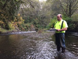 ed by Oregon Department of Environmental Quality (DEQ), NCWA and other stakeholders working within these watersheds to track critical summer water temperature data. The data will be used by DEQ to characterize baseline temperature and trends and assess if the rivers in these watersheds are meeting water quality criteria for salmonid survival.
Project Partners: Oregon Department of Environmental Quality
Project Funders: Oregon Watershed Enhancement Board: $5,665; in-kind match funds from DEQ and NCWA. This is 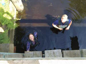 an ongoing project that has received OWEB funding since 2016 with match from DEQ, NCWA, and watershed volunteers
Total Project Cost: $37,565
Completion Year: ongoing effort, current funding through 2021.
You can explore the map below to find the data collected so far or visit the Monitoring Sites page to see a list of sites. Temperature is compared to the ODEQ water quality standard for summertime temperature, which is 18°C for summertime rearing and migration of salmonids. Click pins in the map for more information on each site. Yellow pins represent 2016 sites only, are tidally influenced and potential future sites. Green pins mark 2016-17 monitoring sites. Blue pins are new in 2018. For a more in-depth look, download the Excel files below.
Download the data here: Download the 2016 Data | Download the 2017 Data
Download the 2018 Data
John Day Crossing Restoration Project
Project Summary: This project is located on a tidal reach of an unnamed John Day River tributary that passes under North John Day River Road through two 60 inch culverts. The undersized culverts restrict natural hydrologic function, create a fish passage velocity barrier, and lead to annual flooding. This project involves removing the two culverts, replacing them with a 61 foot bridge and raising the low stretch of the road above the 100-year flood elevation.
After project completion, salmonids and other aquatic species will have unrestricted access to an additional 22 acres of high quality tidal wetlands and local residents will have safe passage to and from their homes throughout the year.
Project Partners: Clatsop County, Columbia River Estuary Study Taskforce (CREST)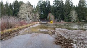
Project Funders: Oregon Watershed Enhancement Board: $177,167; Bonneville Power Administration: $308,308; US Fish and Wildlife Service Partners funding: $100,000; Clatsop County: $79,773; NOAA funding pending
Total Project Cost: $860,890
Completion Year: 2020